Council sends all redistricting maps back to the drawing board

by Steven Felschundneff | steven@claremont-courier.com
On Tuesday, Claremont City Council got a look at the draft maps for the upcoming reconfiguring of council districts, and pretty much sent the entire lot packing.
Just three years ago the city council adopted the current council district map after voting in November 2018 to transition from at-large to district-based elections. However, those districts were based on 2010 U.S. Census data and by federal law must be redrawn to reflect demographic changes revealed by the 2020 Census.
To comply with the Citizens Voting Rights Act, Claremont chose to establish council districts during a time when many cities with at-large elections were being sued, and essentially forced to switch to district elections. Since then, the districts have been fraught with problems, and many, but not all residents, would like to return to at-large elections.
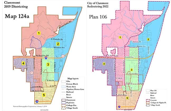
Following a contentious selection process, the council narrowly approved its initial map in February 2019. Drawn by National Demographics Corporation, that map featured both “regional” and “vertical” components, and divided some traditional neighborhoods. The vertical components, as the name suggests, linked neighborhoods in different parts of town to promote cooperation and avoid dividing the city into blocks of economically advantaged and disadvantaged voters.
Claremont is in the unusual position of having three of its councilmembers — Jennifer Stark, Mayor Jed Leano and Mayor Pro Tem Ed Reece, who were all elected in the city’s final at-large election — up for reelection in 2022. Corey Calaycay, who represents District 1, and Sal Medina, District 5, were elected during the first district election in 2020.
“Every ten years, local governments use new Census data to redraw their district lines to reflect how local populations have changed. Assembly Bill 849 requires cities and counties to engage communities in the redistricting process by holding public hearings and/or workshops and doing public outreach,” city officials said in a statement.
Redistricting will largely be an exercise in rebalancing the current districts to bring the city into compliance with state and federal statutes. The most important of these is adjusting the district boundaries so that there is less than 10% difference between the most and least populous.
Following two previous public hearings National Demographics Corporation began with the existing district map and tweaked it to create several new maps that rebalanced the population distribution while attempting to account for input from residents.
Tuesday was the third public hearing for the redistricting process, during which the council reviewed seven maps, five of which were drawn by National Demographics Corporation. The two additional submissions include map 101, drawn by a citizen, which did not balance the population among districts so it was a redrawn by NDC to make it balanced and resubmitted as map 101 revised.
Councilmember Jennifer Stark began the discussion by noting that none of the maps seemed to take into account public input from the previous meetings, specifically the desire by people living in certain communities to be united with neighbors to whom they feel connected. This includes people living in the residential area of the Village and a small community of older homes roughly bordered by Foothill Boulevard, Mills Avenue, Blaisdell Drive and Claremont Boulevard.
Councilmember Sal Medina also expressed his desire to see the traditional Latino neighborhood of Arbol Verde remain in District 5.
Robert McEntire and Douglas Johnson of National Demographic Corporation were on hand to address questions from council, but at times had trouble following individual instructions. They were, however, quite open to council suggestions.
The council seemed to agree on eliminating maps 101 and 101 revised, and settled on map 106 or one like it, which deviated the least from our current district map. Mayor Pro Tem Ed Reece had also drawn a map, which he planned to give to McEntire and Johnson.
The residential area of the Village is currently split down the middle at Indian Hill with one portion in District 1 and the remainder in District 3. Reuniting the two halves seemed to be a shared goal of the council, however to do so could create another problem because District 1 voted in the city council election in 2020 but District 3 did not. Depending on how the map is redrawn, Village area voters currently in District 3 could find themselves in District 1 and would have to sit out another election cycle.
This possibility drew the attention of Mayor Jed Leano, who expressed concern about the appearance of disenfranchisement. He asked McEntire and Johnson to provide hard numbers associated with any new map showing how many voters would be forced to sit out two elections.
McEntire and Johnson indicated they would compile the council’s suggestions and reconfigure the maps by “the end of the week.” That short turnaround reflects the dwindling timeline — the council must select a map during its next meeting on March 8.


0 Comments