

From rural town to suburb: 70-plus years of growth in Claremont

This 1952 aerial view of Claremont has a series of small arrows that seem to point toward areas in town that are either under construction or have recently been developed. The 1950s and 1960s were boom years for Claremont, a time when most of the citrus groves were replaced with housing. Courier photo/Robert Frampton
by Steven Felschundneff | steven@claremont-courier.com
The buzz around Claremont these days centers around how much the town has changed, and not for the better.
People decry the loss of the small town charm that was so abundant a short time ago. They say the Claremont they knew is slowly being supplanted by urbanization. For evidence, look no further than the proposed South Village development with its 705 new residences and 144,417 square feet of new commercial space. That same development will include five-story buildings, which is still unheard of here save for a couple of dormitories at the Claremont Colleges.
Still others welcome the changes and believe the city will be a better place as a result of the new high-density development. South Village, with its small apartments, will provide housing for people who may not otherwise be able to afford to live here, and its single-story flats will create options for retirees. Our modern Village with its numerous busy stores and abundant nightlife seems to many like a vast improvement over a time when we “rolled up the sidewalks” at 5 p.m.
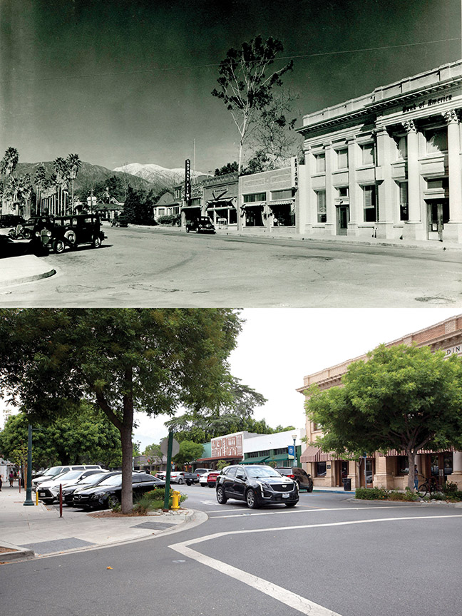
Yale Avenue looking north from Second Street circa 1934 and today. Seen at right is the Verbal building which was Bank of America at the time. Southern California Edison was in the building next to the bank and the space to the north, currently the Folk Music Center, was a hardware store. Vintage photo/by Loyd Cooper, courtesy of City of Claremont History Collection, The Claremont Colleges Digital Library; Courier photo/Steven Felschundneff
And if you think the recent changes around here have been startling, it’s informative to take a look back at Claremont just after World War II.
Claremont 70 years ago looked more like a rural farming community than a suburb of the Los Angeles metropolis. The Claremont Colleges set the town apart from others in the Pomona Valley, but if you left campus and headed in any direction and you would soon have been in the midst of vast citrus groves or an endless thicket of native chaparral.
People described the night view of the valley from Mt. Baldy Road as a “diamond necklace” because each town was like a jewel of streetlights distinctly separated from the next by the vast open spaces between.
But right after the war a great metamorphosis began in Southern California, and it literally did not stop until the suburbs stretched from the sea to the mountains. The boom was part of a great migration west driven by the promise of plentiful jobs and mild winters. The aerospace industry was a significant local driver with General Dynamics and Lockheed employing thousands, and all of those workers were looking for a piece of the California dream.
During this same time tract homes started to replace agriculture in Claremont at a rapid pace. According to the U.S. Census, Claremont’s population doubled every 10 years beginning in the 1940s, ballooning from just 3,057 people in 1940 to 24,776 in 1970, an 800% increase.
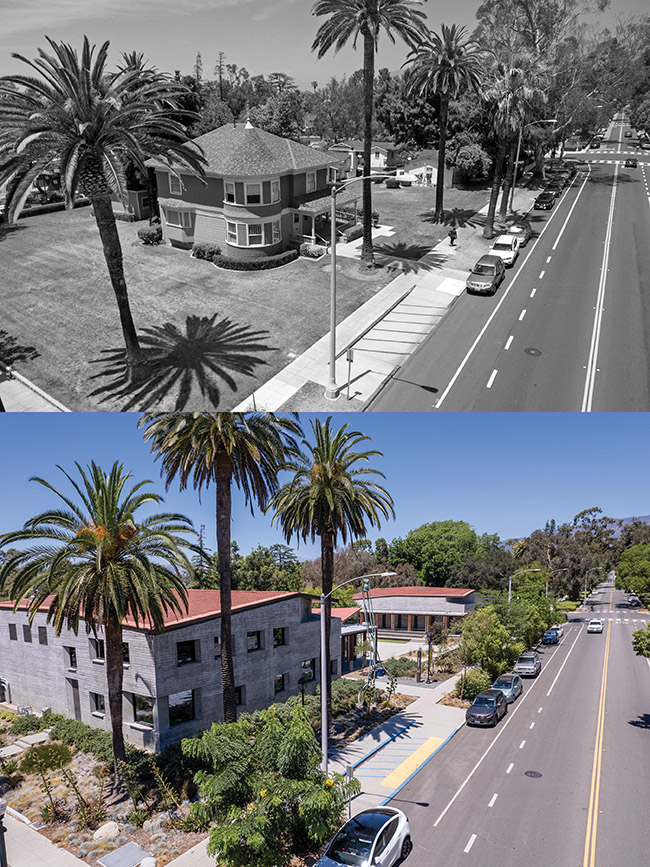
The Renwick House is seen at its original location on the corner of Second Street and College Avenue in May 2016. Now, of course, this is the location of Pomona College’s Benton Museum of Art. Vintage Courier photo/Peter Weinberger; current Courier photo/Matt Weinberger
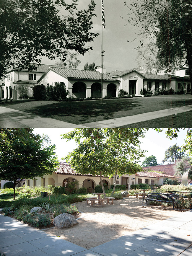
Claremont City Hall in November 1951 and today from the corner of Second Street and Harvard Avenue in the Village. Vintage photo/by Dean Granger, courtesy of City of Claremont History Collection, The Claremont Colleges Digital Library; Courier photo/Steven Felschundneff
In the 1950s most of the development occurred in the south part of town and some adjacent to the Village. By the 1960s the majority of the residential areas between Foothill Boulevard and Base Line Road were built. In the 1970s the construction shifted to above Base Line.
With the new homes came school-age children, and from the mid 1950s to the late 1960s, Claremont built all its elementary schools — except Sycamore — two middle schools, and replaced its high school.
The whirlwind of development left many Claremonters in shock about how quickly everything was changing and how it was affecting the economy. According to John Neiuber, who writes the “From the Files of Claremont Heritage” column for the Courier, as the citrus industry faded many of the businesses that catered to the farmers struggled. In addition, the Colleges were expanding and could no longer source the supplies needed to support the faculty and students by “shopping local” and started working with a food service company.
This caused a great deal of consternation among local merchants, so in 1961 the Claremont Chamber of Commerce came up with an idea: from now on, the commercial area would no longer be known as the central business district, but would be called the “Claremont Village.” The thinking was a name change would attract new specialty stores that were slowly replacing the general stores of the past.
As evidenced by the minutes of City Council meetings, many residents were sure this change would be the death of all the businesses that were just hanging on. But the Village survived and many of our cherished older stores and restaurants were founded during this era.
Twenty years ago the proposed construction of Village West had people riled up, insisting it would kill all the businesses in the “traditional” Village. But, of course, it was the opposite. The Village is more popular than ever, and the two “halves” are impossible to separate.
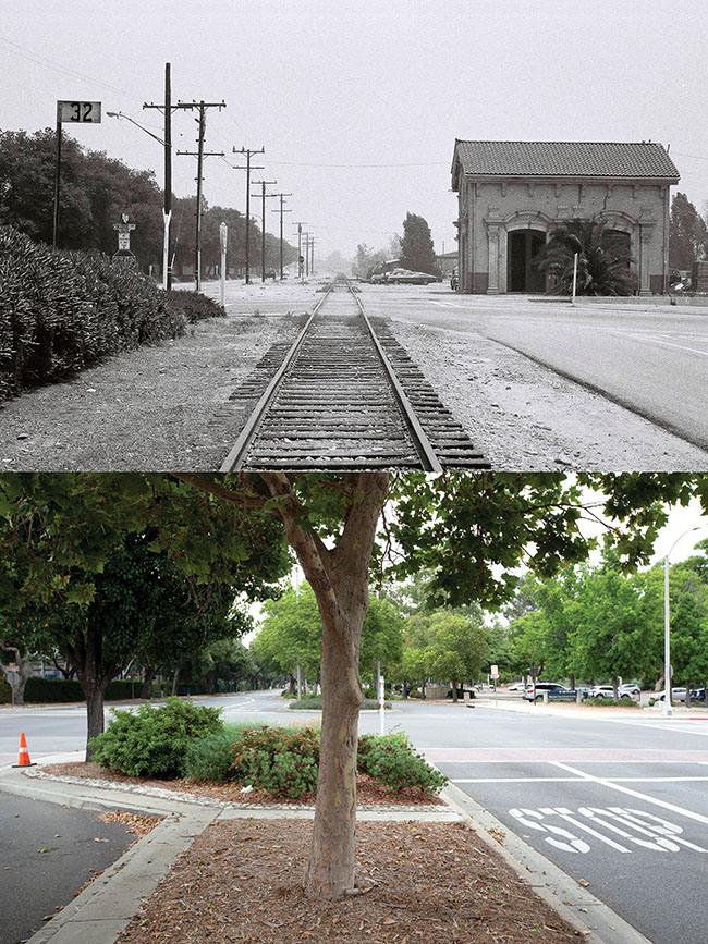
Vintage photo circa 1970 showing Claremont’s Pacific Electric station and the long decommissioned light rail tracks adjacent to First Street at College Avenue in the Village, with Pomona College on the left. Vintage photo/Courier file; current Courier photo/Steven Felschundneff
In the mid 1970s towns like Claremont started reevaluating growth and what had been lost in the process. Many historical structures were torn down as the city grew and the Claremont Colleges expanded. The loss of three in particular, a craftsman called the Woodford house, the old Claremont Inn on College Avenue, and the original Claremont Public Library, were the inspiration for establishing Claremont Heritage in 1976. Around this same time historian and former Mayor Judy Wright began the first registry of historic homes in Claremont.
According to Neiuber, there is a danger zone for buildings that are 30 to 50 years old. That’s when they are seen as out-of-date and not fashionable, but also not historic, and therefore can be replaced with little thought. He points to the lack of Victorian homes in Claremont as a prime example. It’s not that Victorians never existed; they were all demolished. The one remaining true example of a Queen Anne Victorian, Sumner House on the Pomona College Campus, was moved here in 1901.
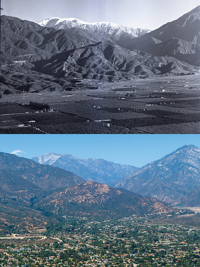
Mt. San Antonio and the San Gabriel mountains haven’t changed much since the top photo was taken in 1938, but the valley below has been transformed from mostly citrus groves to a sea of houses. Vintage photo/by Loyd Cooper, courtesy of City of Claremont History Collection, The Claremont Colleges Digital Library; Courier photo/Matt Weinberger
After 1980 growth all but stopped. For the next 40 years every time the census came around Claremont’s population had increased by single digits, the largest being 6.7% between 2010 and 2020. Claremont’s population has actually shrunk by 3.4% to 36,001 since the 2020 count when it was 37,261, according to an estimate from the U.S. Census.
Why this occurred is no mystery. Sometime in the mid-1980s the city was “built out,” meaning there was little vacant land left on which to construct houses. During this era home construction was largely infill on smaller plots of vacant land surrounded by existing neighborhoods.
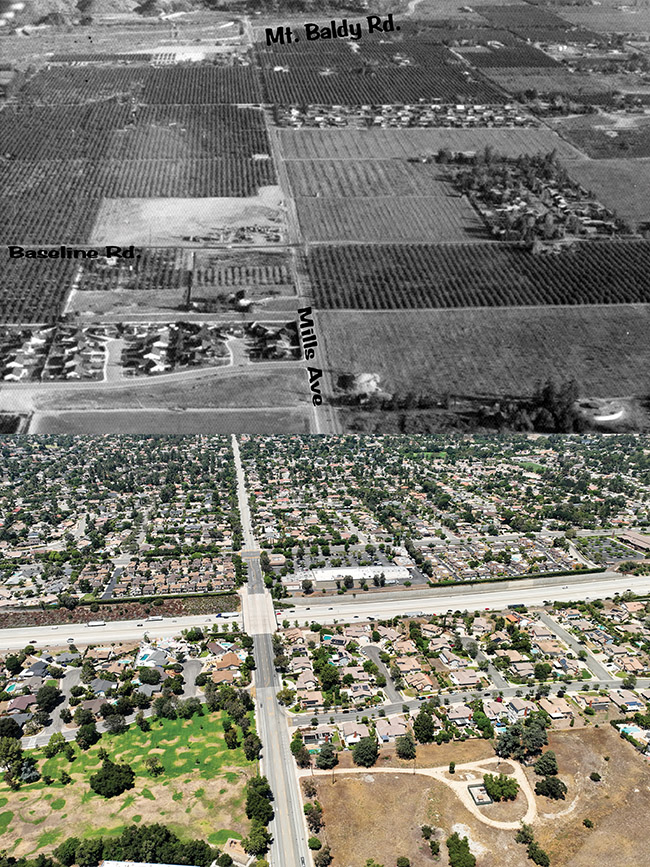
The intersection of Base Line Road and Mills Avenue shown in 1970 and today. Beginning at the top of the vintage photo the three tracts of homes are located on Bluefield Drive, Claremont Heights Drive, center right, and Radcliff Drive. Vintage photo/Courier file; current Courier photo/Matt Weinberger
As shown in 1965 satellite images of Claremont, there were still large swaths of citrus groves in the north part of town and vast sections of chaparral on the eastern border. In a similar photo taken in 1983, all that open space has been replaced by housing.
An interesting side note: from the very beginning, regardless of the year or who was in charge, residents have always felt the Claremont Village had a parking problem. People complained about parking during every decade, Neiuber said. Even in the 1910s folks were worried that catering to the parking needs of motor vehicles would mean a loss of convenient places to tie up a horse and wagon.


0 Comments