Hurricane Hilary brings historic storm warning to SoCal

by Steven Felschundneff | steven@claremont-courier.com
It’s looking more and more likely that a powerful tropical storm from a degraded Hurricane Hilary will make landfall in Southern California Sunday, with possible flooding in Claremont.
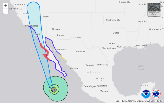
For the first time in its history, the National Weather Service on Friday issued a tropical storm watch for California. The first winds could be here as early as Sunday morning, but the storm is not expected to enter United States territory until late Sunday or early Monday.
According to the NWS, while Hilary strengthened to a category 4 storm on Friday, it is expected to lose energy as it moves north over cooler waters in the coming days and will likely be downgraded to a tropical storm by the time it reaches the southland. The weather service also predicts a moderate chance of flooding in Claremont and of strong winds gusts up to 30 mph.
If your home has experienced flooding in the past, the City of Claremont is making sandbags available at its Los Angeles County Fire stations including Station 101, 606 W. Bonita Ave.; Station 102, 2040 Sumner Ave.; and Station 62, 3701 N. Mills Ave. It is recommended that you bring a shovel or other tool to fill the bags.
The weather service predicts two to four inches of rain for the San Gabriel Valley with more likely in the mountains. The most intense rains are expected in the California deserts.
If Hilary actually hits California it will be the first tropical storm here in 84 years, according to CNN.
Hilary’s current track has it passing to the east of Claremont, but tropical storms are quite wide, so if that track holds the effects could be felt as far west as Santa Maria and Phoenix, Arizona to the east, according to a National Weather Service map.


0 Comments