Claremont adopts new district map, but many left dissatisfied

by Steven Felschundneff | steven@claremont-courier.com
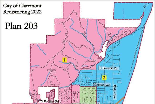
Following a lengthy debate, including one final opportunity for public comment, the Claremont City Council selected a new council district map on Tuesday, narrowly staying on schedule to meet a fast-approaching deadline for the 2022 election. By a unanimous vote, the council eliminated eight other choices and settled on map 203, described as a “small scale change” design.
To say it was nobody’s first pick would be the understatement of the year. Like the shy kid sitting in the back of the classroom, map 203 was not even mentioned by a single councilmember until the last half hour of the almost five hour-deliberation. At one point there was even confusion about whether it was still in the running.
The council described the map as a compromise, partially uniting some traditional neighborhoods, while dividing others. By largely sticking with the existing district boundaries, it was also one of the least disruptive, resulting in a small amount of temporary voter disenfranchisement.
The only clear winners Tuesday night were the people in the tiny neighborhood of older homes just northeast of Foothill Boulevard and Mills Avenue. That area will now be in the same district as portions of the Village, an expressed priority of resident Jennifer Jaffe.
Reacting to a string of demand letters sent to other California cities warning that at-large elections violated the state’s Citizens Voting Rights Act, Claremont leaders proactively decided in 2018 to divide the city into five council districts. The original district map adopted in 2019 was based on 2010 U.S. Census data, but federal law requires the city to revisit its map to reflect demographic changes revealed by the 2020 Census.
Redistricting is largely an exercise in adjusting the current boundaries so that the most populous district has fewer than 10% more people than the least populous district. But city leaders can also consider less easy to define parameters, such as established neighborhoods or “communities of interest.” The Citizens Voting Rights Act requires that any protected class of voters not be concentrated in one district or diluted among many districts. Above all else, the districts cannot violate the Federal Voting Rights Act or have racial gerrymandering.
Starting in January, the city held three public hearings to gain input from Claremont residents about where they would like the new council boundaries to be drawn. Feedback largely centered on ensuring established neighborhoods remained intact. Several people who live in the residential area of the Village, which had been split up the middle at Indian Hill Boulevard, expressed interest in reuniting that area into a single district. Councilmember Sal Medina requested that Arbol Verde, the traditionally Hispanic neighborhood, remain in District 5.
Tuesday’s discussions were civil but highly entrenched, with long pauses during which the council fell completely silent, even with Mayor Jed Leano’s continued prodding to keep the conversation active. They considered some sweeping changes, most of which were brought up during public comment, including immediately returning to at-large elections, requiring the entire council to rerun for office, renumbering the districts and going through the redistricting process again in two years.
The most radical ideas were abandoned immediately, mainly because they were not in keeping with the law or would create more problems down the line. Abandoning districts altogether received more serious debate, but unknown financial risks and a desire to not be the “Guinea pig” for such a move ultimately resulted in tabling that one, too.
Councilmember Corey Calaycay called on his colleagues to lobby state lawmakers to amend the Citizens Voting Rights Act so that small cities like Claremont were exempt from the districting requirement. If that were to occur, the council seemed united in the desire to trigger a clause in the 2019 ordinance that would reestablish at-large elections. This solution also received wide support from Claremont’s citizens.
Deliberations over the nine maps largely centered on two conflicting priorities. A plan to radically redraw the districts to be “highly regional” and the desire to minimize the number of Claremont voters forced to sit out two election cycles because of the redistricting process.
The overarching conflict as described by Douglas Johnson of National Demographic Corporation lay in the absence of a realistic way to achieve both goals. Maps 206 and 207 posed the fewest voter disruptions, but achieved almost no other goals, including those brought up during the three previous public hearings. Maps 209 and 208 abandoned the “vertical” design of the current map in favor of more compact “regional” districts but resulted in between 3,000 and 3,900 effective disenfranchisements. No matter how the district lines were drawn, as the map became more regional, the number of voters left in the cold increased.
Councilmember Jennifer Stark led the charge for a complete reimagining of the districts, expressing her desire to change the map to comply with the “California criteria” by making districts compact, having identifiable boundaries, being geographically contiguous with undivided neighborhoods and prioritizing “communities of interest.”
The maps she favored included only one or two districts above Base Line, eliminating the current situation in which three sitting councilmembers, including herself, live in the north part of town, which has the lowest population density but the highest level of wealth. This approach was favored by several residents who spoke during public comment.
The other side of the debate, championed by Mayor Leano and Councilmember Medina, favored balancing the population to comply with federal law but keeping the districts largely the same.
Mayor Leano expressed a desire to prioritize “people over places” and had reservations about telling thousands of Claremont voters they would have to sit out an election because the council wanted to reunite the Village under one councilmember.
Medina said he legally could not vote until he was well into his adult years and as a result has voted in every election since. As such, he had trouble casting a vote that would cause others to have their voices delayed.
As the hour approached midnight, the council settled on three maps 203, 205 and 207. Seeing little support for the regional approach, Stark became a champion of the least disruptive choice and put forward a motion to approve map 207, which would balance the population by literally transferr one neighborhood from District 2 to District 3, creating no significant disenfranchisement.
However, Stark revoked her motion because Calaycay expressed an interest in having a roll call vote on map 205, which largely unites the Village but would result in 2,358 voters being forced to sit out the election. That motion failed by a 3-2 vote with Mayor Pro Tem Ed Reece and Calaycay voting yes.
Districts 2, 3 and 4 will vote this November while districts 1 and 5 will vote in 2024. As such any voter moved from a district that votes this year to one that votes in two years will have sat out two consecutive voting cycles.
Map 203 expands District 3, currently represented by Stark, into portions of Districts 1, 2 and 5. It partially achieves the goal of uniting the Village with select neighborhoods west of Indian Hill, east of Cambridge Avenue, south of Foothill and north of Eighth Street joining District 3. A four-block notch between Eighth and Tenth streets, and west of Oxford Avenue remains in District 1. A mixed residential and commercial zone south of Sixth Street, east of Indian Hill, west of College Avenue and north of Bonita Avenue also moves to District 3. And of course Jaffe’s neighborhood as well.
The trade-off comes in the neighborhood north of Base Line Road, east of Indian Hill, south of Armstrong Drive and west of Forbes Avenue where 356 voters, including this COURIER reporter, will have to sit out their second consecutive local election.
Pilgrim Place, a definite community of interest, will remain split between districts 1 and 4, in keeping with the wishes of its residents.
The council will hear a second reading of the motion to approve its new map during the March 22 meeting, giving the city plenty of time to meet the April 17 deadline to finalize the map.


0 Comments