Most of Baldy Village saved from Bridge Fire

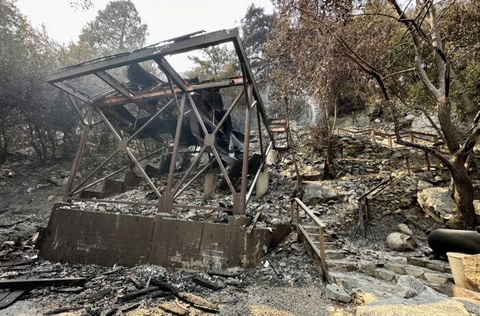
One of several homes lost to the rapidly advancing Bridge Fire on Tuesday in the Bear Canyon area of Mt. Baldy Village. Courier photo/Peter Weinberger
by Mick Rhodes | editor@claremont-courier.com
At press time Thursday, more than 400 firefighters on the ground and in the air had mercifully begun to slow the massive Bridge Fire’s advance, saving most of Mt. Baldy Village and keeping the blaze from making its way into the southern foothill communities, including Claremont.
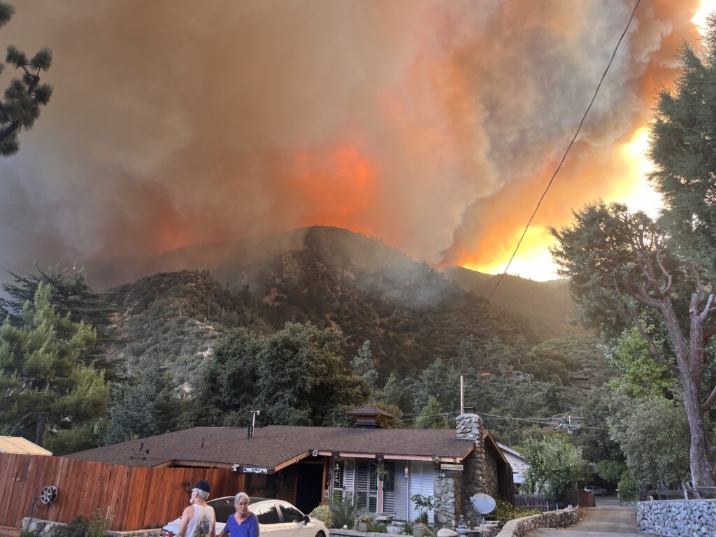
The fast moving fire burned into Mt. Baldy Village late Tuesday afternoon. Fire crews scrambled to the area but were unable to save the 20 homes that burned there.
There have been no injuries to residents, firefighters or police reported thus far.
North Claremont residents were advised to prepare to evacuate on Wednesday, and the evacuation warning remains in effect. The massive plumes of smoke and debris that had been erupting ominously from the fire and blowing to the east since Sunday had dissipated by Thursday, with firefighters aided by cooler temperatures and higher humidity.

This photo from Tuesday afternoon shows the Bridge Fire advancing into the Mt. Baldy Village area near the Mt. Baldy Lodge, with residents preparing to flee. Photo/by David Mix
The Bridge Fire has been burning since 2:12 p.m. Sunday. It had consumed 51,884 acres as of 3 p.m. Friday, with 3% containment. Along with destroying 20 homes in the Mt. Baldy area, it has also claimed 13 in Wrightwood, six cabins in the wilderness area, and damaged the power infrastructure in Wrightwood.
In a 9:15 a.m. update on Thursday, California Air Agency Incident Management Team 5 Operations Section Chief Spencer Andreis said the fire along Mt. Baldy Road directly above Claremont “is hung up along the road system — which is good — it’s all hanging on the west side.” Andreis said things were going “really well” in the Mt. Baldy area. “Yesterday we had very favorable conditions. The smoke emergence stayed down, so fire conditions remained denied for the most part, which was really good and advantageous for our crews. They continue to mop up, patrol, work amongst the structures that we did lose in the days prior to.”
The fire grew alarmingly fast. It was at 3,786 acres Tuesday morning, but after exhibiting “extreme fire behavior” overnight, exploded to 47,904 acres by 9:30 a.m. Wednesday. Massive plumes were visible from across the Inland Empire foothill corridor, into the San Gabriel Valley, and in Orange County. The air in north Claremont was sickly yellow and thick with ash and fine particles on Monday, prompting Claremont Unified School District to keep students indoors at each of its 10 locations. By Wednesday the air had cleared enough to allow students to resume outdoor activities.
The Thursday evening update from California Air Agency Incident Management Team 5 added some detail to the work crews are doing in the Mt. Baldy area.
“On the east side, firefighters continue using Mt. Baldy Road to hold the fire, which is slowly backing from the west,” read the CAAI Team 5 update. “Along the foothills, the southern flank of the fire has shown little movement, allowing firefighters to construct direct line along the fire’s edge, as well as crews strengthening containment lines by clearing and widening Sunset Peak Road with dozers and hand crews. Crews are monitoring and extinguishing hotspots in the fire’s perimeter up the southwest flank and are feeling confident they can hold containment lines. Air attack continues to monitor fire activity in the steep terrain along of the west flank.”
Andreis said the fire was also “hung up,” meaning it was not advancing, in the San Dimas Canyon area. It has pushed north into Wrightwood and the Table Mountain area, with crews continuing to use bulldozers to stop its advance there and mop up and patrol in areas where the fire has been extinguished.
Thursday evening’s update described what transpired throughout the day:
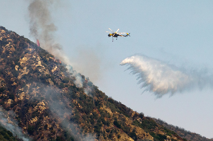
“Today, the Bridge Fire saw minimal growth across the entire fire perimeter due to decreased wind speeds and higher relative humidity. Water and retardant-dropping aircraft worked throughout the day, cooling hotspots with water and painting the ridge lines with fire retardant on the northwest side of the fire where heat was detected. Hand crews, dozers, and engines aggressively attacked the fire on the north flank to slow growth. Protecting structures within the affected communities remains the top priority for the fire crews. A smaller crew camp has been established on the fire’s north side to shorten driving distances and response time.”

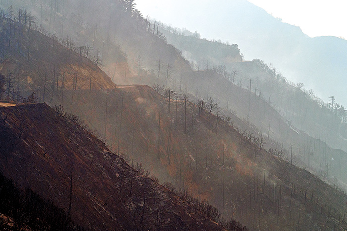
Looking north from Glendora Mountain Road at the smoldering foliage with Mt. Baldy in the background, at about 5 p.m. Wednesday. Courier photo/Peter Weinberger
On Wednesday, CAAI Management Team 5 Public Information Officer Lisa Cox said those under evacuation warnings, including north Claremont residents and Upland residents in the San Antonio Heights area from the 210 freeway north, should “Make sure that you have a go bag ready with your very important essentials, prescriptions, important papers, anything like that. Make sure your pets have a place to go.”
“I want to say thank you to the people who have heeded all the evacuation orders and warnings,” Cox said. “Because people listen to those, our firefighters were able to actually get into those communities and do structure protection the way they need to do it.”
The fire grew massively on its north and east flanks overnight Tuesday. “The top priority for firefighters remained in structure protection and defense within the communities of Wrightwood, Pinon Hills and Mount Baldy,” read the Wednesday morning update from California Air Agency Incident Management Team 5. “Despite the extreme fire behavior, lack of resources, and challenges firefighters had, they successfully defended homes, and no communication towers went down. Firefighters held the lines they had west of Mount Baldy Road, and they continued to prioritize securing contingency lines to the south. By the public heeding evacuations, firefighters were able to get in and engage in the structure defense they needed to.”
Evacuation orders remained in effect Thursday for Mt. Baldy Road, all residents north of the San Antonio Dam up to the Mt. Baldy Resort; the entire community of Wrightwood; Pinion Hills from Wrightwood north to Highway 18 and Beekley Road west to LA County; Pinion Hills from Wrightwood north to Highway 138 and Lebec Road west to LA County; Lone Pine Canyon from Wrightwood to Hwy 138/Lone Pine Canyon Road south to the forest; and the East Fork communities of Camp Williams Resort and River Community.
For the latest updates on the fire, go to inciweb.wildfire.gov/incident-information/caanf-bridge-fire. Additional information, including some dramatic video, has been posted on the Angeles National Forest Facebook page at facebook.com/angelesnationalforest.
The cause of the fire remains under investigation.

A firefighting helicopter dumps a load of water on the Bridge Fire Wednesday afternoon near Mt. Baldy Village. Courier photo/Peter Weinberger


0 Comments