Drone spends nine months on Mt. Whitney

by Peter Weinberger | pweinberger@claremont-courier.com
Misfortune follows everyone around on occasion and sometimes, you wonder why it’s directed your way. Then, in a split second, news arrives and everything changes for the better. That’s exactly what happened when I was on assignment in the Sierra Nevada taking aerial photos and videos.
This road trip headed 202 miles to the north, up Highway 395 to Lone Pine. The Sierra Nevada mountain range was directly to our west, including Mt. Whitney, the highest mountain in the continental US at 14,505 feet.
It was easy to find the Whitney Portal Road in downtown Lone Pine, then head west driving 14 miles directly toward Mt. Whitney. There’s a 4,647 foot elevation increase on the way to the parking and picnic area at the 8,400 foot Whitney Portal.
The peaks surround hikers with the afternoon light blazing and the trailhead is well marked and even has a store with plenty of hiking supplies. Since the trail to the top of Whitney is 22.3-mile round trip, some hikers start very early in the morning and hike it in one day. But most camp out one night. This trek is only for experienced hikers in excellent condition.
I wanted to photograph this portion of the mountain range by taking the drone up to 10,100 feet.
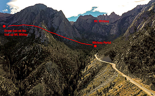
I hiked up the Whitney trail a half-mile to find a spot appropriate for piloting my drone. No one was around making it easy to find spectacular views. I increased the drone’s altitude and quickly got a birds-eye view of the Lone Pine Creek.
That’s when the drone stopped responding to any of my controls. At a time like this, I fly up to have a better chance of getting a stronger signal and avoid interference. But after moving to several positions and trying to link signals, the controller went dark and I was unable to connect to the drone again. It was lost on 9/14/2019.
The hardest part was the loss a day’s worth of incredible images, almost filling a 64gb SD card. Some of these around the Lone Pine area were unique, given the locations were rarely, if ever, photographed. It was not a good day.
Only later did I learn that drones don’t do well in high altitude, especially over 10,000 feet. At least that’s what drone builder DJI says. I actually had given up on the project, not wanting to risk losing another drone.
Months later I received a phone call from someone who did not identify himself but said he had something that belonged to me. Given all the scams out there, I did not call back. A month went by when I was contacted again. This time it was through Facebook, so I was able to confirm who it was. Christian Ray is a crime scene investigator for the Inyo County Sheriff’s Office in Bishop. Once she sent a photo of the drone, I put it all together thinking the unbelievable had just happened.
I’ll concede the trail up Mt. Whitney is well traveled. But there’s only one trail. And it’s in a massive wilderness at high altitude. Out of all the directions a drone could fly on its own, this one decided to land near the summit trail, next to Lone Pine Lake at 10,000 feet, over one mile from where I was originally standing. Did I just win the lottery? If the drone landed 20-30 feet in a different direction, it could have been gone forever.
Let’s not forget the hiker who took time to drop off the drone to the local sheriff’s office on June 24. My drone spent nine months outside where snow covers the ground much of the year. Still stuck on the top was its FAA ID number and my telephone number.
When the drone was finally delivered to my door on September 4, I was shocked to see its condition. The front legs were broken, but everything else was intact. The battery was dead, but immediately charged up. There were stains and dirt marks, but it looked clean. The drone spent a winter at 10,000 feet in the California High Sierra and lived to see another day.
Best of all, the SD card downloaded my 4k video and RAW photos just like normal. The images were saved! Including the unseen 10-minute video clip of its final flight.
Viewing the final clip, the drone continued to follow the Lone Pine River up the mountain. As the elevation increased, it finally passed right along treetops, narrowly avoiding a crash.
To find out what happened to the drone, check out my video from that day on claremont-courier.com and our Facebook page.


0 Comments